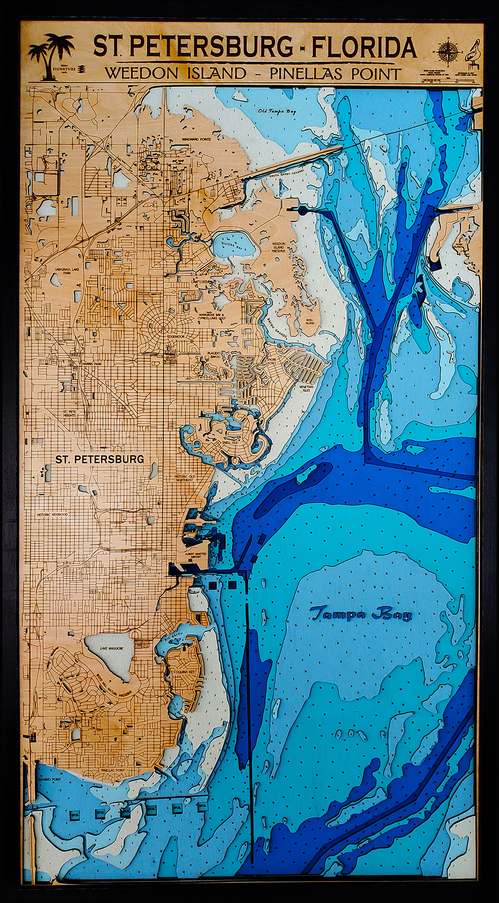
Has anyone attempted a bathymetric lake map that includes a road map around the lake? Like this one: 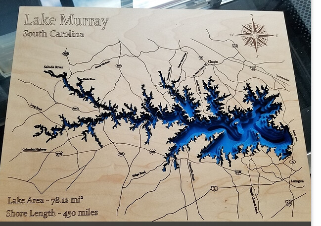
I’m wondering if anyone knows where they might have sourced a simple map like that which includes the highway numbers/names and some town names?
Has anyone attempted a bathymetric lake map that includes a road map around the lake? Like this one:
I’m wondering if anyone knows where they might have sourced a simple map like that which includes the highway numbers/names and some town names?
Searching the forum will return several posts about mapping and how to generate the maps you’d like. Everything from using a screenshot of Google Maps, to full-fledged GIS mapping systems to generate the exact view and look to the maps you make. You have many options. 
I do them every day. I’m a cartographer and GIS scientist. The problem most folks run into is not understanding the data that is available. Being an expert in vector design is critical to using GIS data. It’s challenging but also very rewarding.
Dang, I forget how nice your work looks. Just great @animapper!
Wow Dean…That looks spectacular!
I’ve been using QGIS with Openstreet or Google maps for my roads. For the contours I use google earth and overlay the data (usually a PDF) them and trace. Many of the lakes I want to use don’t have electronic data available or at least I haven’t been able to locate it yet. Then I export the contours as a .kml and import to QGIS that way everything lines up with the roads and map. I then have to export the roads to Inkscape to union and group. I had always wondered if people added the highway numbers and town/city names manually or if it was done another way?
Thanks Rick - I’m slowly getting my whole library converted to LB, It takes a while! BTW, this is a great example in this thread of the need to have the “remove duplicate lines” feature. When roads come in they have at least an inside line, an outside line and a centerline. I have to use RDworks to remove them before I can go back to LB. The tolerance setting lets me decide how close I want to remove lines.
Hi Benjamin,
Thanks for the kind words.
Our approaches are simply different. There’s nothing ever traced in my work because I have the digital data for everything. Contours are DEMs that can be projected. Symbols, road signs, shipwrecks, salt marshes, labels, titles, continuous and intermittent sea grasses, rock shoals, real depth point data and anything we’ve been studying from the University side all reside in the GIS. QGIS is great but the power tools have a lot more depth when in comes to analytics.
Hey Dean,
You’ll have to excuse my ignorance but I’m fairly new to QGIS and the way mapping works. I understand the concept of contours being projected but sourcing them has proven difficult especially for inland lakes. Oceanic and Great Lake data seem relatively easy to find already in electronic format but most inland lakes are much more difficult to source. I have been trying to figure out if the data from fish finders are downloadable because they have all the data.
Is GIS something that the public has access to or is it just for university use? I’d love to be able to have access to lake depth charts that are electronic or is that something that your University has put together? Do you have Canandaigua lake in Western NY?
Creating a bathymetric lake map that includes a road map around the lake is a cool idea! It can provide a comprehensive view of the area, making it useful for both navigation and appreciating the beauty of the surroundings.
While I’m not sure where to find one exactly like the example you shared, you might want to check out The Lake Clementine Guide To Summer Fun [Updated January 2024]. They offer information about various lake destinations, including Lake Clementine, which could be a source of inspiration for your project. Exploring different lake maps and their features might give you some valuable insights into how to create the perfect map that includes highway numbers, names, and town names.